- Tue 04 June 2024
- data
- #data, #no-code, #cycling, #edinburgh
⭐ Interested in my meetup talk slides or the app itself? Then please scroll down to the Downloads section! 📺 Watch the video here!
Introduction
Edinburgh, with its stunning views of Princes Street and the historic castle, is a city that captivates its visitors. Its charm extends to the narrow, cobblestone streets that invite exploration.
Among the residents, cycling is a popular mode of transport, supported by an extensive network of bike infrastructure. This love for cycling is evident in events like Critical Mass, where cyclists come together to promote road safety.
Yet, despite its beauty and cycling culture, Edinburgh has a notorious problem: potholes!
In this blog article, I show you how I created a mobile app (using no-code) in an attempt to quantify this problem. This quantification of the problem might then help the council to solve the Edinburgh pothole problem.
The app that I made as part of this personal hobby project allows the user to capture pothole locations. You are very much invited to join the data capturing process by downloading the app from the Downloads section so that we can all crowdsource the necessary data together!
The Pothole Problem in Edinburgh
Cycling in Edinburgh offers a sense of freedom. The city’s layout and scenery make it an ideal place for biking, often faster and more economical than other modes of transport. However, the abundance of potholes presents a significant hazard to cyclists. These potholes not only disrupt the smooth flow of travel but also pose safety risks.
Edinburgh’s roads are riddled with potholes, making it one of the worst cities in the UK for road conditions and repair efficiency with news outlets frequently highlighting this issue. These potholes are not just minor inconveniences but can cause significant damage and danger to cyclists.
A Data-Driven Approach Using No-Code
In an attempt to address this problem, I worked on a hobby project: creating a no-code mobile app to collect data on potholes. The goal is to gather comprehensive data, analyze it, and send it to the city council so that they can prioritise repairs based on this analysis.
Why did I use no-code for building the app? No-code development allows for rapid app creation without requiring extensive programming knowledge. For this project, I used the MIT App Inventor, a free and open-source platform that simplifies app development through a block-based interface. This approach is like assembling Lego pieces, making it accessible for anyone to build functional apps quickly.
Building the Pothole Logger App & Results from its Usage
I built the app by following these three steps:
- Designing the App: Using the MIT App Inventor, I designed the app’s interface and logic directly in a web browser.
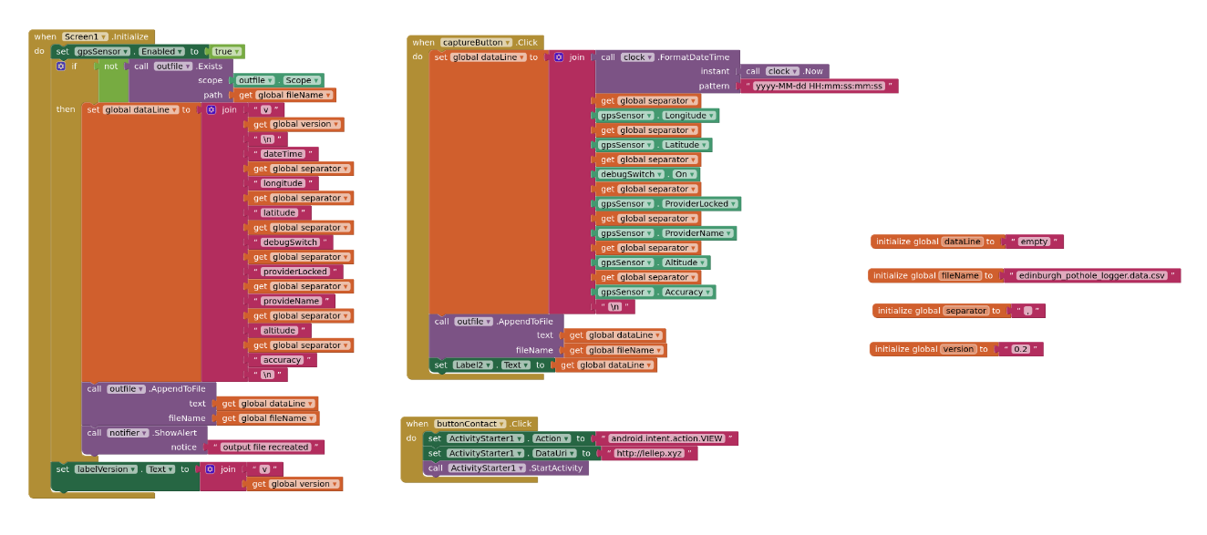
- Implementing Logic: The app’s logic involves enabling GPS, creating a data file to store the pothole locations, and saving coordinates of logged potholes.
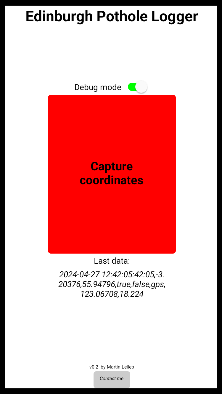
- User Interface: A simple UI with buttons for enabling debug mode, recording coordinates, and sending data files for crowdsourcing purposes ensures ease of use.

The logic of the Edinburgh Pothole Logger app that I built with the MIT App Inventor.
This is how the app works:
- GPS Data Collection: Users can record the GPS coordinates of potholes.
- Data Storage: The app saves these coordinates in a CSV file on the phone.
- Crowdsourcing: Users can send the collected data to me for further analysis.

The UI of the Edinburgh Pothole Logger app.
This is the result of my project as of now: Using the app, I mapped 123 potholes along Gorgie Road, highlighting the uneven distribution of potholes. Some areas are densely packed with potholes, while others are relatively smooth.

Result of my experiment: I found 123 potholes along Gorgie Road!
Conclusion
Building this app took me without any prior knowledge only a few hours on six days over several weekends, proving that no-code tools like the MIT App Inventor can significantly accelerate project development. Whether for work or personal projects, I encourage you to explore no-code solutions!
If you’re interested in more details, you can find my corresponding meetup presentation slides and the app itself below in the Downloads section. This is a recording of the presentation!
If you feel super motivated, please feel free to help capturing pothole data using my app so that the data analysis becomes more comprehensive! 🤗 Feel free to get in touch via LinkedIn in this case.
Future steps are:
- Data Submission: Sending the collected data to the council, for example through the government road defect form.
- Data Analysis: Further analysis could correlate pothole density with council tax bands, providing additional insights for a cost-effective solution of the pothole problem.
Downloads
I gave a talk about this project at Tech Meetup Edinburgh on 2024-06-04! Find the slides here:
I will add the slides here after my meetup talk on 2024-06-04!
To use the app yourself, download it here:
The ZIP file consists of both the installable .apk file for Android and the .aia project file which you can open in MIT App Inventor yourself to, for example, base your app off of mine.

